|
USAPhotoMaps
suppports direct ForeRunner data importation, but uses
www.terraserve.com for it's base maps, which is 10 year old data, and thus
most of my neighborhood does not exist. Plus, it's a Windows program, and I don't
really run Windows unless absolutely necessary.
Garmin MapSource
supports plotting gps tracks on a map, but I don't believe that it supports plotting
on aerial or satelite photos. Plus, it too is a Windows program.
These tools should work with a
ForeRunner 101 (if it had a serial interface, that is) and with the ForeRunner 301
(but heart rate data would not be displayed), but since I don't own either of those,
I can't say for certain. I notice that Garmin has released a 205 and 305 and I
would hope that these would also work with this software, but once again, since I
don't own one, I can't guarantee it. I'll also look into adding support for the
output from the Training Center application if need be.
You're welcome to send me the XML file from a ForeRunner
205, 301, 305 (or 101 if you can get it out) and I'll see if it can't be easily supported.
Other GPS units may also be
supportable, but I'd need detailed track data and information on file formats (or
at least a couple of examples) to add support for them.
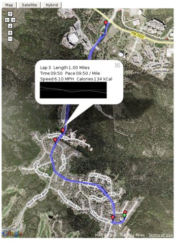
At present, things are fairly stable. The web tools work fine if
given a proper base map to plot on and basemap generation is mostly automated, save
for the trial and error of getting the alignment offsets correct. I have mostly
switched away from the original version in favor of using the Google Maps API. This
provides a much simpler solution (since I don't need to generate the base maps anymore,
but does so at the cost of the pace and elevation graphs). The elevation graphs are
available in the Google version by clicking on the lap markers and a popup will display
with that lap's elevation inforamtion. I'll probably add the pace graph in a similar
way.
Comments and suggestions are welcome, please use the bug tracker tool to do so.
|